-
Sun 12th Feb 2012 05:50 #1 / 23
Hello everyone, first time here. I was thinking the other day that I was never happy with the Risk board; things like the shape of Ukraine, and with China having a population 5000 times larger than Iceland. I thought I'd search to see if anyone had tried making changes and came across this website.
I've browsed the very interesting boards on this site - I particularly like the World reversed - but they seem to have different numbers of territories or hugely different topology. I was thinking of keeping the Earth, 42 territories and 6 continents, but just altering some borders/shapes/names and using population and land area statistics to balance the globe better. It will be subjective - lots of the USA was uninhabitable centuries ago but is now well populated, and Siberia may be more populated in future centuries...
So, just to check if anyone has any ideas or has already seen any work on this?
-
Sun 12th Feb 2012 10:02 #2 / 23
-
 Sun 12th Feb 2012 10:09 #3 / 23
So that reply was only tangentially related and not especially helpful, but your question reminded me of it; and I thought I would share the laugh.
-
Sun 12th Feb 2012 20:09 #4 / 23
"If an incompetent chieftain is removed, seldom do we appoint his highest-ranking subordinate to his place" - Attila the Hun
Ian James wrote:
Hello everyone, first time here. I was thinking the other day that I was never happy with the Risk board; things like the shape of Ukraine, and with China having a population 5000 times larger than Iceland. I thought I'd search to see if anyone had tried making changes and came across this website.
I've browsed the very interesting boards on this site - I particularly like the World reversed - but they seem to have different numbers of territories or hugely different topology. I was thinking of keeping the Earth, 42 territories and 6 continents, but just altering some borders/shapes/names and using population and land area statistics to balance the globe better. It will be subjective - lots of the USA was uninhabitable centuries ago but is now well populated, and Siberia may be more populated in future centuries...
So, just to check if anyone has any ideas or has already seen any work on this?
@ Cramchackle: Too funny!
@Ian: Your idea sounds like a cool concept and a different twist on the standard risk map. Can't wait to see what you come up with!
-
Sun 12th Feb 2012 20:28 #5 / 23
I've enjoyed looking at cartograms and have seen a few that would make nice maps -
From Wikipedia -
A cartogram is a map in which some thematic mapping variable – such as travel time or Gross National Product – is substituted for land area or distance. The geometry or space of the map is distorted in order to convey the information of this alternate variable. There are two main types of cartograms: area and distance cartograms.
-
Mon 13th Feb 2012 11:43 #6 / 23
Ad Extremum Omnia Sunt Limosus
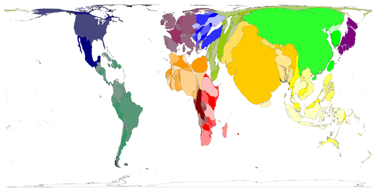
"In Spring 2000 world population estimates reached 6 billion; that is 6
thousand million. The distribution of the earth's population is shown in this
map"Edited Mon 13th Feb 11:50 [history]
-
Mon 20th Feb 2012 12:45 #7 / 23
Thanks All! Cramchackle - lots of smiles for me in there. Although I like Isaac Asimov and buy Organic?! And I'll have to go an read up on the difference between Gall Peters and Hobo Dyer.
That population map is amazing. Mongolia has vanished!
As you might guess from my tardy reply it may be several weeks before I have something to post.
-
Thu 15th Mar 2012 20:34 #8 / 23
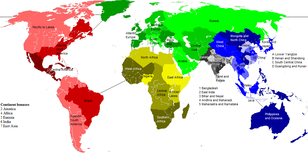
Change of plan - I've designed a Risk map with 42 territories of roughly equal population. I took longer over this than I planned so it may well be months before I do a land area version, if at all!
I made them all between 5/4 and 4/5 of the average population size of 164,188, so they are all between 200,000 and 130,000. This meant splitting China, India, USA and Indonesia (and I split Canada too), which I did using their highest level of administrative divisions. China and India comprise 8 territories each!
Country populations are at 1 July 2010 from "Total Population - Both Sexes" at http://esa.un.org/unpd/wpp/Excel-Data/population.htm. ; Division populations are from Wikipedia and scaled to match the UN country populations.
All comments welcome! Here we go - my names, population in thousands, and specification:
Brazil 194,946
South America 197,608
Central America 197,527 includes Caribbean
Pacific to Lakes 182,437 West, Midwest, OK, AK, TN, KY, WV; Ontario westwards
Atlantic North America 162,092 VT, PE, coast from ME to LA; QC, NL, NB, NS, PE
Atlantic Europe 186,800 Iceland, UK, Eire, coast from Monaco to Portugal
North Europe 190,101 Belarus, Luxembourg, Scandinavia, coast from Estonia to Belgium
Russia 142,958
Black Sea 150,754 Turkey, Bulgaria, Romania, Moldova, Ukraine
South Europe 140,337 All bordering Albania, Bosnia or Austria except Germany
North Africa 165,907 Coast from Western Sahara to Egypt
Western Africa 145,838 All bordering Burkina Faso, Senegal or Guinea
Nigeria 158,423
Central Africa 139,778 Chad, Central African Republic, Zambia, coast from Cameroon to Angola
Southern Africa 132,528 Malawi, Madagascar, all bordering South Africa
Great African Lakes 137,785 Kenya, Uganda, Rwanda, Burundi and Tanzania
East Africa 141,975 South Sudan, coast from Sudan to Somalia
Arabia 146,963 Cyprus, all bordering Saudi or Lebanon
Central Asia 178,391 All bordering Uzbekistan or Azerbaijan
Pakistan 173,593
North India 168,410 Delhi, Himachal, the border from Rajasthan to Uttarkhand
Uttar Pradesh 197,843
Narmada 134,213 Gujarat and Madhya
Maharastra and Karnataka178,238 includes Goa
Tamil and Kerala 134,600 Sri Lanka, Maldives, Puducherry, Tamil Nadu and Kerala
Andhra and Mahanadi 159,334 Andhra, Chhattisgarh and Orissa
Bihar and Nepal 160,838 Includes Jharkhand
Bhutan and East India 143,000 Bhutan; Sikkim, all bordering Assam
Bangladesh 148,692
West China 157,818 Xinjiang, Qinghai, Tibet, Sichuan and Yunnan
Mongolia and North China169,910 Mongolia; Gansu, Ningxia Hui, all bordering Jilin
Japan and Korea 199,066
Hebei 178,566 Includes Shaanxi, Shanxi, Beijing, Tianjin
Shandong and Henan 191,017
Lower Yangtze 162,198 Shanghai, Jiangsu, Anhui
South East China 160,034 Jiangxi, Fujian, Zhejiang and Taipei
Guangdong and Hunan 187,449 Includes Hong Kong, Macau and Hainan
South Central China 167,912 Hubei, Chongqing, Guizhou and Guangxi
SE Asia 177,310 Thailand, Laos, Vietnam, Cambodia
Andaman Sea 131,814 Sumatra; Singapore, Malaysia, Brunei, Myanmar
Java 142,302
Pacific Islands 178,583 Rest of Indonesia; Oceania, Philippines, East Timor
-
Thu 15th Mar 2012 22:33 #9 / 23
I want to see what this looks like. Do you have the images done?
-
Fri 16th Mar 2012 08:21 #10 / 23
Hi Ozyman, no not yet - not sure how to, I guess I'll get google maps and try and draw over the country boundaries
-
Thu 29th Mar 2012 00:23 #11 / 23
Ian, I have been trying to do the same thing with a board in development, but I was trying to do it with canada. (I noticed a distinct lack of canadian maps - can't have that)
It's super interesting because there is a vast empty space in canada that nobody lives in (or like <0.01 person per square K) and a very small space that 30 million people live in... so the question was, how to simulate huge open spaces? I did it some with unit limits, and some with small numerous territories for the places with lots of people. I also gave more unit bonus for places that were densely populated.
Trying to get the gameplay feeling for what you describing. What I'm finding though, is that "gamplay is like playing catch with spaghetti" to quote Yertle. It's not very balanced, and has a weird strategic element.
So, from a fellow trying to develop his first board in the same way, think about the strategy that will make your map fun to play, and trust me on this one, your probably going to have to sacrifice some accuracy to do it.
Sweet world divisions though... I really dig the idea, and am excited to see how it turns out.
-
Fri 30th Mar 2012 06:58 #12 / 23
Thanks ratsy,
yes, to begin with I split Canada (I didn't want to lump it in with West and Midwest US and have one territory touching both Russia and Europe); but later on I ended up being very mathematical and forgetting about gameplay. So rather than a practical board my result is "Wow - people say England is crowded - wait until you see Java and Uttar Pradesh"
-
Tue 15th Jan 2013 15:29 #13 / 23
-
Tue 15th Jan 2013 15:45 #14 / 23
-
Tue 15th Jan 2013 16:16 #15 / 23
These are great. I had no idea Nigeria was so big -- 162M
-
Wed 16th Jan 2013 10:06 #16 / 23
I'm a man.
the smaller the size on this the more populus, right? the bigger the more sparse?
ah Bangladesh. it's all about perspective. the entire population of the US living in the space of Iowa.
But I can change,
if I have to,
I guess...
-
Sun 3rd Feb 2013 15:39 #17 / 23
Cheers smoke. Spot on weathertop - so Russia's the sparsest, mainly because half its population live in 10% of the land (Volga and Central districts).
Right, here we go with 42 territories based upon land area. I tried to make them all within 20% of the average territory size, so between 2.50 and 3.75 million square kilometres, but the last one is slightly too small. I've often used names of rivers or mountains where territories straddle countries. Country data are from World Bank and exclude lakes. Where I've had to split countries into territories (Russia, Canada, USA, Brazil, Indonesia, Australia, China) I've used Wikipedia data weighted to match World Bank country totals.
My name, million sq km, and specification:
Tasman Sea 3.12 New Zealand; Queensland, New South Wales, Victoria, Tasmania
Australian Bight 3.45 Western and South Australia
Banda Sea 3.44 Northern Territory; Philippines; Indonesia excluding Borneo
SE Asia 2.95 Coast from Bangladesh to Vietnam; Borneo, Laos and Philippines
India 3.22 Includes Nepal and Bhutan
Kush-Zagros 3.70 All bordering Iran except Turkey and Iraq, plus Georgia
Arabia 3.62 All bordering Saudi Arabia
Kazakhstan 3.46 Includes Uzbekistan, Kyrgyzstan and Tajikistan
Xinjiang and Tibet 2.79
Yangtze-Pearl 3.26 Qinghai, Sichuan, Yunnan, Taipei, all bordering Zhejiang and Hunan
Huang-Liau 3.27 Nei Mongol and Hebei and bordering provinces
NW Pacific 3.22 Federal subjects from Chukotka to Primorsky; Japan and both Koreas
Yakutia 2.98
Altai-Transbaikal 3.22 Mongolia, Altai Republic and Russian federal subjects bordering them
Yenisei 2.98 Krasnoyarsk and Irkutsk
Ural 3.32 Volga and Ural federal districts, Tomsk, Omsk and Novosibirsk
Western Russia 2.80 Northwestern, Central, Southern and North Caucasian federal districts
Northeast Europe 3.38 All bordering Baltic Sea, Ukraine and Germany except France & Russia
North Atlantic 2.58 Greenland, Iceland, Ireland, UK
Mediterranean 2.91 Coast from Portugal to Israel, Serbia, Bulgaria
Nile 3.37 Egypt, Sudan, South Sudan
East Africa 3.46 All bordering Ethiopia and Rwanda except both Sudans and Congo
Zambezi 3.46 Angola, Zambia, Zimbabwe, Mozambique, Malawi, Madagascar
Kalahari 3.04 Namibia, Botswana, South Africa, Lesotho, Swaziland
Congo 3.23 Both Congos and Central African Republic
Gulf of Guinea 3.30 Coast from Gambia to Gabon plus Burkina Faso
Libya and Chad 3.02
Western Sahel 3.52 Mauritania, Mali, Niger
Maghreb 2.98 Morocco, Algeria, Tunisia
Atlantic North America 2.92 Coast from Newfoundland to Florida
Nunavut 3.01 Includes Northwest Territories
Yukon 3.01 Alaska, Yukon, British Colombia
Central Canada 2.61 Alberta, Manitoba, Saskatchewan, Ontario
Mississippi basin 3.68 TX OK KS NB SD ND MN WI MI OH WV KY TN AL MS LS AK MI IA IL IN
Western USA 3.02 All states bordering Idaho or Arizona
Caribbean 2.66 Both coasts from Mexico to Panama, Caribbean
Equatorial America 2.61 Coast from French Guyana to Ecuador
Inca 3.11 Peru, Bolivia, Chile
Argentina 2.74
Amazon 3.32 Amapá, Pará, Roraima, Amazonas, Acre
Plata-Mato Grosso 3.22 Paraguay, Uruguay; Goiás, border from Rondônia to São Paulo
East Brazil 2.49 Minas Gerais, Tocantins, coast from Maranhão to Rio de Janeiro
-
Tue 5th Feb 2013 04:48 #18 / 23
And here's the map with the territories according to Land Area.
Ideally I think the board should be somewhere between this and the population version above.
 Edited Tue 5th Feb 04:49 [history]
-
Tue 5th Feb 2013 11:43 #19 / 23
Way Cool.
-
Tue 5th Feb 2013 14:53 #20 / 23
You could combine the two this way:
http://bigthink.com/strange-maps/490-map-of-the-worlds-countries-rearranged-by-population


